1 Introduction
1.1 Background
The hydropower resources in the lower reaches of the Congo River are abundant, and the conditions in these reaches are highly conducive to exploitation.Exploration of the Congo River dates back to the 1970s, when Italian and Belgian design companies conducted research on the hydropower resources of the region [1].The Grand Inga hydropower project, which is one of the major hydropower projects in the region, has consistently attracted attention globally.Inga Phase I (351 MW) and Phase II (1424 MW) were completed and put into operation in 1972 and 1982, respectively.Since the 1990s, western consulting institutions have conducted research on subsequent phases of the Inga hydropower project.However, for various reasons, no substantial progress has yet been made on construction plans for Inga Phase III and subsequent phases.In August 2018, China successfully hosted the Africa Energy Interconnection Development Forum, published the Africa Energy Interconnection Planning Research, and proposed the development planning for The Congo River hydropower base and its transmission projects.In October, 2018, the government of the Democratic Republic of the Congo (D.R.Congo) signed a contract for the construction and development of the Inga III hydropower station in a joint venture between China and Spain.Hydropower development in the lower Congo River has thus entered a new stage.
In addition to the Inga river reach, the lower reaches of the Congo River still have enormous hydropower potential, and no specific research has been carried out in these reaches.Indepth studies of hydropower development planning, project scale and exploitation timing, etc., in the lower reaches of the Congo River are of great significance for the overall development planning of the downstream Congo River hydropower bases and Africa Energy Interconnection.
1.2 Research thinking
Data on the hydrology, topography, and geology of the lower reaches of the Congo River is sparse.Under the existing basic conditions, the current hydrological runoff data and watershed topographic data are collected, analyzed, and reviewed.Then, the main tasks of hydropower development in the lower reaches of the Congo River are identified based on socio-economic status, power development planning, and comprehensive utilization requirements [2].Secondly, main factors influencing hydropower exploitation in different reaches are analyzed, including hydropower resource conditions, river reach topography, reservoir inundation, and ecological protection.Thirdly, according to the Inga III hydropower cascade development plan and the characteristics of receiving- end power load, the recommended cascade plan for the chosen river reach is proposed.Kinetic energy index analysis and simulation of runoff regulation are carried out.The engineering benefits and costs are comprehensively analyzed.Finally, implementation effects and exploitation timing of the cascade development plan are analyzed, and preliminary research on the possible social and environmental impacts are conducted [3, 4].
2 Congo River basin
The Congo River originates from the Zambezi River and the Lovua River.From Kisangani onwards, it is called the Congo River.It has a total length of 4,640 km, a basin area of about 3.7 million km2, and a theoretical hydropower potential of over 300 million kW.It flows northwest through the Boyoma Falls, then turns southwest into a series of canyons, shoals, and waterfalls south of Kinshasa, and finally flows debouches into the Atlantic Ocean near Boma.
The upstream reach, which extends from its origin to Kisangani, is 2,200 km long.The river flows from south to north through areas with high altitude and steep slopes with rapid water flow.The mid-stream reach extends from Kisangani to Kinshasa and is about 1,700 km long.It flows through the central part of the Congo Basin and has many tributaries.
The downstream reach is the portion after Kinshasa.The reach from Kinshasa to Matadi is about 360 km long with a water level drop of about 250 m.The water resources here are abundant, and the development potential is extremely high.The reach from Matadi to the estuary is gentle, wide and deep.The cities of Boma and Soyo are situated along the banks of the river in this reach.This reach has shipping requirements and does not have the conditions conducive for hydropower exploitation.
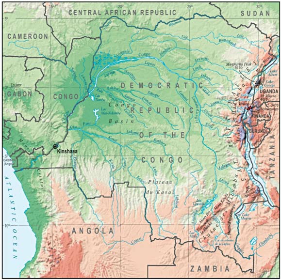
Fig.1 Congo River basin
3 Exploitation conditions
3.1 Hydraulic resource analysis
3.1.1 Runoff Analysis
The Congo River basin is large and located in the area that received the maximum rainfall in Africa.The main stream crosses the equator twice.One-third of the basin is located in the northern hemisphere and two-thirds of the basin is located in the southern hemisphere.Owing to its special geographical location, the intra-annual difference in runoff is relatively small [5].

Fig.2 Monthly mean runoff of Kinshasa hydrological station
At current stage, 90 years of data from 1921 to 2010 Hydrological data provided by GRDC from the Kinshasa hydrological station for the period from 1921 to 2010 (hydrological data from 1984 to 2010 is unofficial) shows that the average annual runoff is about 40, 400 m3/s, and the maximum runoff is over 80, 000 m3/s.The residual mass curve and the inverse accumulation curve are calculated and plotted according to this data, as shown in the following figure.From the residual mass curve, the runoff series exhibits fluctuation between rich, common, and dry water periods.From the mean cumulation curve, the average value has stabilized during the 70 years from 1940 to 2010.This shows that the Kinshasa hydrological station runoff series has a certain representativeness, but needs further validation.At the same time, the Congo River runoff exhibits an increasing trend in recent years.The area of the Congo River from Kinshasa to the estuary is relatively small, and the runoff of each reach is derived from the hydrological data of the Kinshasa hydrological station.
3.1.2 Potential energy analysis
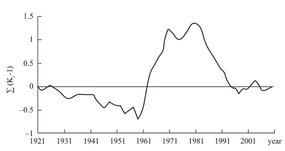
Fig.3 The residual mass curve of runoff data from Kinshasa hydrological station
According to satellite imagery and ASTER GDEM elevation data, the reaches below Kinshasa have a height difference of about 260 m and a length of about 490 km, with an average gradient of 0.53‰.The river channel is flat and there are falls and waterfalls in some areas.The maximum river channel drop in the Inga River reach is 3.27‰, and the river channel drop below Matadi is less than 0.1‰.
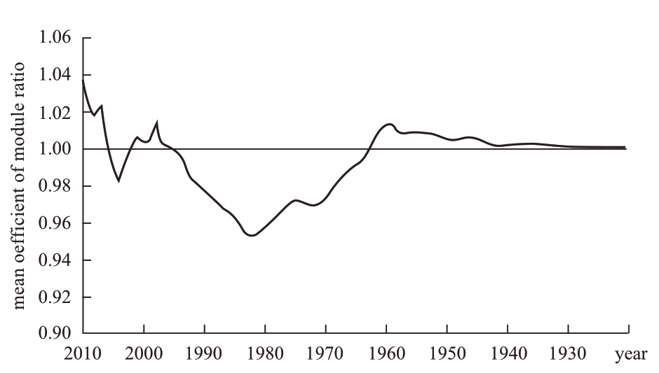
Fig.4 The mean cumulation curve of runoff data from Kinshasa hydrological station
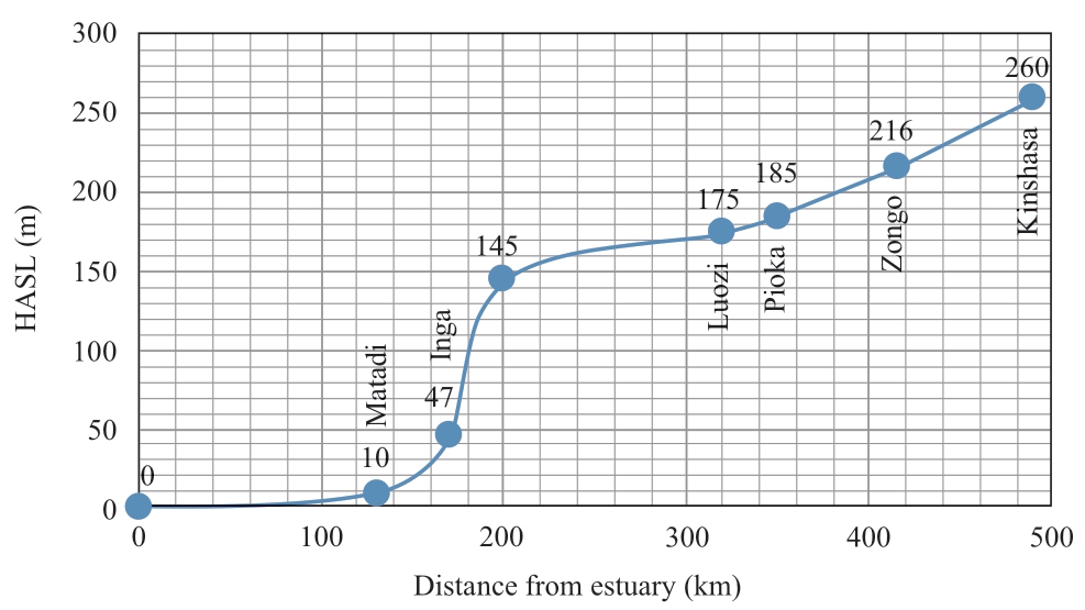
Fig.5 Longitudinal section of the main stream in the lower reaches of the Congo River
According to the potential energy formula of water, the theoretical hydropower potential of the river is given by:
where E is the theoretical hydropower potential, ρWater is the density of water, gi is the acceleration due to gravity, hi is the difference in the river reach, Qi is the average runoff of the river i, T is the h number of the whole year, i is the serial number of the river, and n is the number of river reaches.
Using the equation above, the theoretical hydropower potential in the lower reaches of the Congo River is calculated to be about 880 TWh/year.Of this, the theoretical hydropower potential from Kinshasa to Matadi is about 850 TWh/year.
3.2 Regional geology and seismicity
The Congo Basin is mainly composed of Mesozoic to Cenozoic strata and modern sediments.Fire sediments of Pan-African period are distributed along the margin of the basin [6].According to the United States Geological Survey, the fortification level of the main stream in the lower reaches is that the acceleration of peak ground motion with an exceeding probability of 10% in 50 years is approximately 0.2 m/s2 [7].
3.3 Power consumption
The lower reaches of the Congo River are mainly located in the D.R.Congo.The population of the D.R.Congo is 81.34 million.Its economic development mainly depends on industries such as agriculture, forestry, mining, and food processing.In recent years, the macro economy has maintained steady growth.The average annual GDP growth rate during 2013~2017 was 6.2%.The power demand of the D.R.Congo shows a high potential for future growth, but this demand is not anticipated to match the large amount of power generated from the Inga hydropower station and downstream cascade power stations.The downstream Congo River hydropower bases, as the core of the Africa Energy Interconnection, will send power to other parts of the continent to promote economic development and clean energy development in African countries [8, 9].
3.3.1 Factors influencing reach exploitation Urban inundation
Two large cities, Kinshasa and Matadi, are situated in the lower reaches of the Congo River.Hydropower exploitation should avoid flooding large cities and minimize the impact of power station operations on the lives of residents.
Luozi is a medium-sized town in the Pioka reach between the D.R.Congo and the Republic of the Congo.The urban area measures about 15 km2, and contains about 5, 000 houses.The urban population reaches tens of thousands.Luozi is situated at an elevation of about 175 m and is affected by the Grand Inga Reservoir program, which is a sensitive topic related to the inundation issue.
The remaining downstream reaches of the main stream have few houses or cultivated land, and comprise mainly undeveloped forests.
3.3.2 Ecological flow
The Grand Inga HPP is developed by intercepting water diverted from the Bandi Valley After the dam is constructed across the river, a dewatering reach of about 30 km will be formed.It is necessary to discharge the ecological flow and supply the ecological demand of the downstream river.
The ecological flow analysis needs to comprehensively include the requirements of the ecological demand of the dewatering river reach.It also reflects the relationship between economic development and ecological protection.The annual average runoff in the Inga reach is about 42,000 m3/s, the average runoff in August is about 32,000 m3/s, and the historical minimum daily runoff is about 21,000 m3/s.
Considering 10% of the runoff during the dry period, the ecological power station will discharge about 3,000 m3/s, and the Inga I and II hydropower stations will discharge about 3,000 m3/s, totaling 6,000 m3/s.This is a hypothesis of current planning research, and it requires further in-depth research that takes into account environmental protection objectives.
3.3.3 Inundation influence of the Zongo II HPP
The Zongo II HPP is located in the town of Zongo, about 75 km downstream of the capital, Kinshasa.It is diverted from the Inkisi River to the Congo River to generate electricity to meet the industrial and residential electricity requirements of Kinshasa.The installed capacity of the hydropower station is 150 MW, and the annual power generation is about 861.9 GWh [10].In September 2017, the first unit was put into operation.The tail water elevation of the hydropower station is about 220 m, and cascade exploitation may submerge the powerhouse.
4 Exploitation task of the reach
The channels in the lower reaches of the Congo River are relatively narrow, and the mountains on both sides are low-lying.They do not have the topographical conditions necessary for the construction of large reservoirs.Therefore, the cascade exploitation of the river reaches cannot undertake flood control tasks.The coastline of the D.R.Congo is very short—the Congo River is the only seaport.There are some waterfalls in the lower reaches of Kinshasa.Navigation in only possible in certain reaches and the golden waterway from Kinshasa to Matadi cannot be opened.Cascade hydropower exploitation will help river channelization and enhance shipping capacity.
The main task of hydropower exploitation in the lower reaches of the Congo River is to build a clean energy base, while actively creating a golden waterway for Kinshasa.
5 Drawing up and analysis of reach exploitation plan
According to the comprehensive exploitation conditions of the reach, the lower reaches of the Congo River are divided into three sections, namely, the Jinshasa-Pioka reach, the Inga reach, and the Inga-Matadi reach.These sections will be studied individually, and a plan will be devised for the entire reach.
5.1 Exploitation plan of the Inga reach
A great deal of research on the hydropower development of the Inga Reach has been conducted globally.However, due to its huge scale and the unique characteristics of the exploitation plan, there are still some differences.
For the Grand Inga Hydropower Station, the construction of a dam and an ecological power station in the upper reaches of the intake of Inga I & II has been planned.Using the river valley terrain, the project will intercept and divert water to the lower reaches of the Inga section.Town for 4 kilometers, and the main powerhouse is constructed 4 km downstream of Inga town.
The Grand Inga Hydropower Station generates electricity by diverting water straight from the Bandi Valley, a paleo river.Compared with the huge runoff of the river, the reservoir storage is small, and the conditions are only conducive for exploitation as a runoff or daily regulation hydropower station.

Fig.6 Diagram of exploitation plan for the Grand Inga HPP
5.1.1 Full Supply Level (FSL) of the Grand Inga reservoir
The water head of the Grand Inga Hydropower Station consists of two parts.One is obtained by intercepting bends and diverting water from the Bandi Valley, and the other is the head raised by the dam built on the Inga reach.As a medium water head Power Station, the head change has a significant impact on the installed capacity.
Considering the topographic conditions of the dam site, the upper limit of the FSL is about 205 m.At present, in the preliminary scheme of the Inga III HPS, the FSL is 205 m [11], with a utilization water head of about 150 m.The scheme retained the early design, while it did not conduct in-depth studies on the area submerged by the reservoir and on immigrants.
There are two main problems with the FSL 205 m scheme of the Grand Inga HPP.
Firstly, the FSL 205 m scheme will cause significant inundation of the city of Luozi.According to current topographic data, more than 50% of Luozi lies below an elevation of 205 m and will be inundated, and tens of thousands of people will be affected.The investment required to compensate the affected residents is relatively large [12, 13].

Fig.7 Inundation area of Luozi by the Grand Inga HPP with high dam
Secondly, the reservoir area of the FSL 205 m scheme extends across Congo (DRC) and Congo (Bulgaria).The hydrological elevation of the Pioka boundary section is about 185 m.If the FSL is 205 m, the tail portion of the reservoir will be located in the Congo (DRC) and Congo (Bu) boundary reaches.The ownership of the hydropower station development would belong to the two countries, and the rights and interests of the collaborative development project would be more complex.
However, raising the FSL can increase the utilization water head of the power station by about 20%, increase the storage and installed capacity of the reservoir, and make the power station achieve daily regulation performance.
Therefore, research on the Grand Inga HPP can be divided into high dam scheme (FSL 205 m) and low dam scheme (FSL 175 m).
With the development of the city, the size of Luozi is becoming larger and larger, and the inundation loss is increasing.The exploitation of hydropower should minimize the inundation area of Luozi.
5.1.2 Installation capacity of the Grand Inga HPP
The FSL has a great influence on the installed capacity of the Grand Inga HPP.If the FSL is 175 m, the utilization water head of the power station is about 128 m.
Energy produced by hydropower station is calculated by the following equations:

where Ni,t is power output, ηtub is turbine efficiency, ηgen is generator efficiency, Hτ is the utilized water head, Q is the turbine discharge, hp is the reservoir water level, hd is the powerhouse water level, k is the coefficient of water head loss, I is the inflow, Qe is the ecological flow, E is the average annual generation, T is the hour number of the whole year, and n is the year number.
Through simulations of long-term operation of the hydropower station and energy production calculations, a preliminary comparison and selection of installed capacity is carried out.The results are tabulated below.
Table 1 Kinetic energy indicators of different installed capacities of the Grand Inga HPP
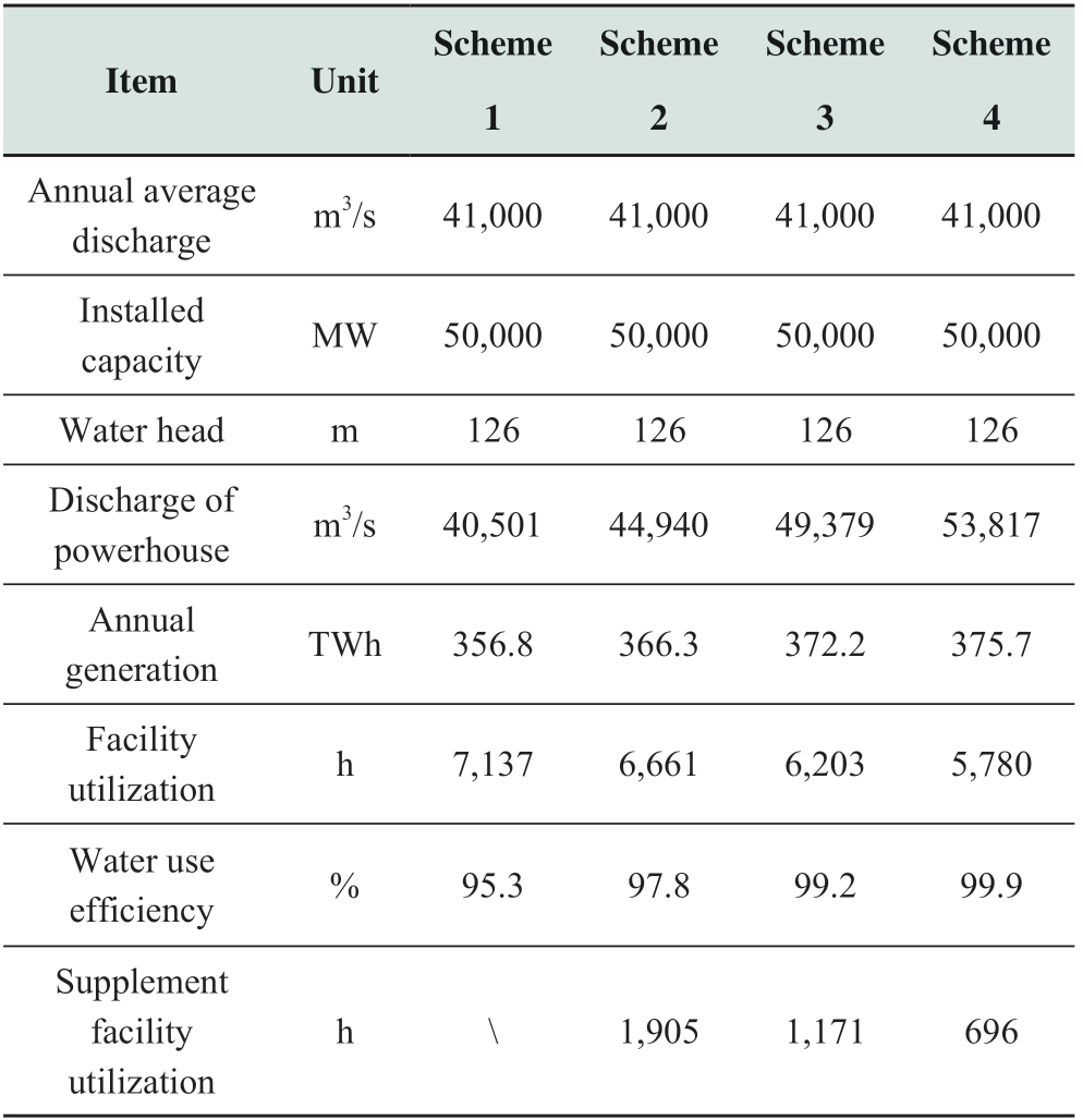
The Grand Inga HPP is large in scale and its facility utilization hours are too high to be used for long-distance power transmission and consumption.Besides industrial loads such as aluminum electrolysis and steelmaking, the power station will not match the utilization hours of other loads, which will result in a certain amount of peak shaving and surplus water.Appropriate increase in installed capacity can reduce the facility utilization hours of the power station, make full use of water energy, enhance the peak shaving capacity of the power station and reduce the amount of abandoned water.The economic index of the Grand Inga HPP is excellent.The electricity cost is estimated at about 2-3 cent/kWh [14, 15], and the scale benefit of the project can be better brought into play by appropriately increasing the installed capacity.
According to the preliminary study, considering the economic benefits of hydropower development and transmission projects, the installed capacity of the Grand Inga HPP is 55,000~60,000 MW, the corresponding facility utilization hours are about 6,600~6,200 hours, and the supplement facility utilization hours are 1,900~1,100 hours.
If the high dam scheme is adopted, the installed capacity of the Grand Inga HPP is 65,000~70,000 MW, which is economical and reasonable.The corresponding facility utilization hours are 6,700~6,300 hours and the supplementary installed utilization hours are 1,600~1,000 hours.
The Grand Inga HPP is a mega hydropower project with unique resource conditions and a complex exploitation mode.The electricity consumption demand and load characteristics of the power market also restrict the scale of hydropower exploitation.In the follow-up, it is necessary to optimize the installed capacity of the project by a comprehensive comparison of energy production costs and project costs.
5.1.3 Reservoir storage and regulation performance analysis
Based on 30 m resolution digital elevation data, the storage capacity of the reservoir is estimated to be 5.4 billion m3 under the FSL 175 m scheme.With the minimum operation level of 168 m, the available reservoir storage is about 1 billion m3.
The main powerhouse of the power plant has a discharge of about 45,000~50,000 m3/s.During the dry season, the power plant can operate for about 14 hours at full peak load, and has incomplete day regulation performance.
5.2 Exploitation plan of the Kinshasa-Pioka reach
The length of the main stream of the Congo River from Kinshasa to Luozi is about 140 km, with a drop of about 75 m and an average gradient of 0.54%.
The main considerations of the cascade exploitation plan are as follows:
(1) The lowest water level in Kinshasa is about 250 m, which is the upper limit of reservoir submergence control.
(2) Make full use of the water head by connecting to the reservoir of the Grand Inga HPP.
(3) The valley between Kinshasa and Luozi is narrow, and no large towns exist.Hence, the reservoir inundation impact is minimal.
(4) The exploitation will have an impact on the Zongo II HPP.The installed capacity of the Zongo II HPP is about 150 MW, and the tailrace elevation of the powerhouse is about 220 m.
If the Grand Inga HPP is developed using the low dam scheme, considering the river topography, water head utilization and reservoir inundation, the exploitation plan of the Kinshasa-Pioka Reach can be divided into one-cascade exploitation and two-cascade exploitation.
The available water head from Kinshasa to Luozi is about 73 m.As the inundation area and number of immigrants is not large, it is economical to implement one-cascade exploitation, which involves a smaller investment and larger available storage.In addition, in terms of unit manufacturing, with a rated head of 73 m, the powerhouse can use largersized Francis turbines, and will thus require fewer units.Furthermore, the powerhouse will be relatively small.
If the river section is divided into two cascades, the area inundated by the reservoir can be reduced, the submersion of the Zongo II powerhouse can be avoided, and the investment in land expropriation and immigration can be reduced.However, each hydropower station would use a water head of 30~40 m and would be a low-head, large-flow hydropower project.The number of units would be high, the powerhouse would be large, and the project investment would increase significantly.According to calculations, two-cascade development reduces the total installed capacity by 3,000 MW.However, the available reservoir storage is small, which is helpful for daily peak shaving.
According to one-cascade exploitation, the Pioka (high) HPP is planned.It is located about 10 km upstream of Luozi Town.The tail of the reservoir submerges the suburbs of Kinshasa.The length of the reservoir is about 140 km.The utilized water head is about 73 m.The dam site is located in Congo (Kinshasa), and the reservoir area includes Congo (Kinshasa) and Congo (Bu).

Fig.8 Dam site and reservoir of the Pioka (high) HPP
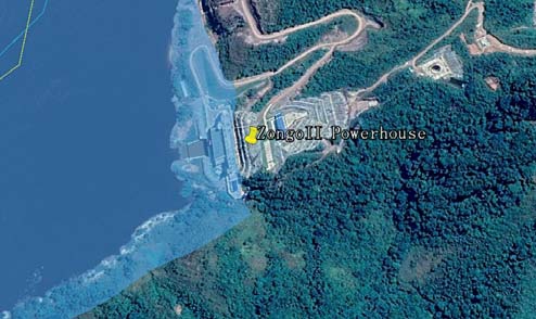
Fig.9 Pioka (high) reservoir inundates Zongo II powerhouse
The installed capacity of the hydropower station is about 35,000 MW, the annual average generation is 221.2 TWh, the discharge of powerhouse is 55,000 m3/s, and the facility utilization hours are 6,320 hours.
If the Grand Inga HPP adopts the high dam scheme, the upper cascade, the Pioka (low) HPP, is located 45 km upstream of Pioka.The utilized water head is 45 m.The installed capacity is about 20,000 MW, the average annual generation is 128.7 TWh, and the facility utilization hours are 6,500 h.
5.3 Exploitation plan of the Inga-Matadi reach
The main stream of the Congo River is about 40 km in length from Inga to Matadi, with a drop of about 37 m and an average gradient of 0.93‰.
The main considerations of the cascade exploitation plan are as follows:
(1) The FSL of the Matadi HPP is related to the tail reservoir level of the Grand Inga.
(2) The inundation of Matadi should be avoided and the impact of construction and operation on the city should be reduced.
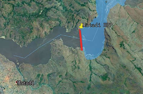
Fig.10 Dam site and reservoir of the Matadi HPP
The Inga-Matadi reach exhibits a small gradient, a narrow valley, does not contain important towns, and is not affected by other sensitive factors.It is designed to be exploited as one cascade, named the Matadi HPP.The dam site is located in the upper reaches of Matadi City.The reservoir extends to the tailrace of the Grand Inga powerhouse.The length of the reservoir is about 30 km, and the utilized water head is about 30 m.
The installed capacity of the Matadi HPP is about 15,000 MW, the annual average generation is about 91.6 TWh, the discharge of powerhouse is 54,000 m3/s, and the facility utilization hours are 6,100 hours.
5.4 Comparison of different cascade exploitation schemes
Analysis of Project Scale In the high dam scheme of the Grand Inga HPP, the total installed capacity is 105 GW and the average annual generation is 659.4 TWh in the lower reaches of the Congo River.In comparison, in the low dam scheme of the Grand Inga HPP, the total installed capacity is 110 GW and the average annual generation is 685.0 TWh in the lower reaches of the Congo River.
According to calculations, there is a little difference between the two development schemes in the total installed capacity and generation.However, separately, the installed capacity of the Grand Inga with a high dam is increased by 10,000 MW compared with that of a low dam, while the installed capacity of the Pioka HPP is reduced by 15,000 MW.
Table 2 Kinetic energy indicators of cascade HPPs in the lower Congo River (Scheme 1)
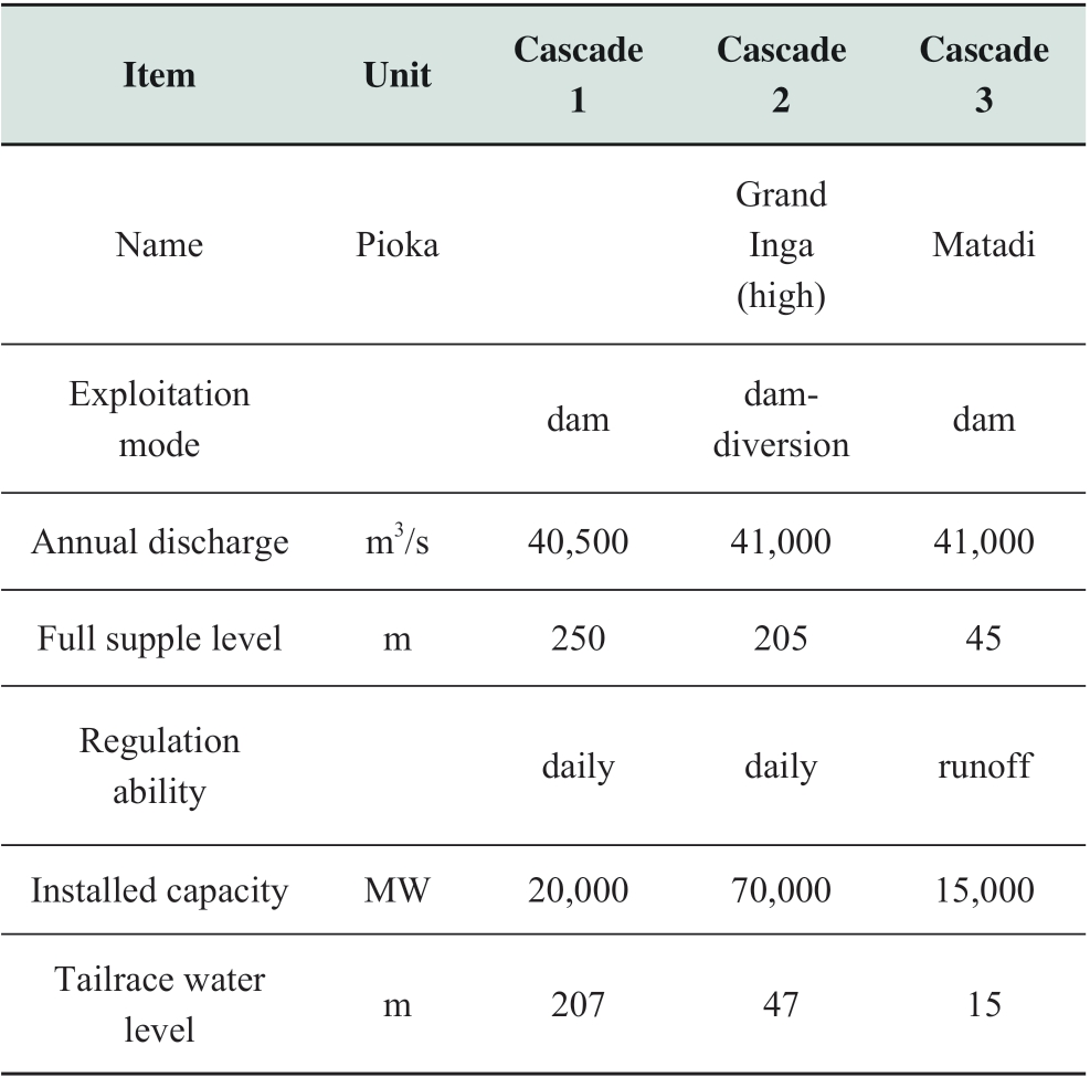
continue
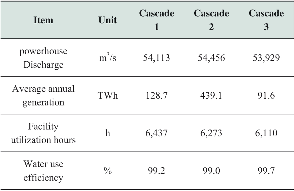
Table 3 Kinetic energy indicators of cascade HPPs in the lower Congo River (Scheme 2)

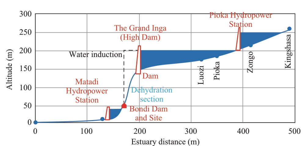
Fig.11 Longitudinal section of cascade development in the downstream Congo River (scheme 1)

Fig.12 Longitudinal section of cascade development in the downstream Congo River (scheme 2)

Fig.13 Monthly average power output of the three cascades
Because of the huge scale of the downstream cascade of the Congo River, there are certain risks in electricity consumption and fund raising.The development conditions and economic indicators of the Grand Inga HPP are much better than those of the other two cascades, so the exploitation plans of the other two cascades are uncertain and the exploitation timing is relatively late.Based on considerations of increasing the scale of the project in the near future, the high dam scheme of the Grand Inga HPP is preferable.
However, the high dam project will cause a large-scale inundation of Luozi Town, displacing tens of thousands of residents.The huge investment required for compensation and resettlement may also cause a series of social problems.Considering the construction of the mega hydropower base in the lower reaches of the Congo River, the low dam scheme only has a few differences from the overall scale of the mega hydropower base, and greatly reduces the investment required for the resettlement of migrants, which is helpful to accelerate the development of the Inga HPP.Therefore, considering the long-term plan of exploitation, the low dam scheme is more friendly and feasible.
6 Opinions on implementation and development impact
For the mega hydropower base in the lower reaches of the Congo River, a 3-cascade HPP has been planned with a total utilization water head of 233 m, a total installed capacity of 104,000 MW, and an average annual generation of 679.9 TWh.
The Grand Inga HPP has a mega scale and excellent economic feasibility.It is suitable for priority implementation.It will be implemented in stages according to the power transmission and consumption scheme.The Matadi HPP is a low water head project, with a smaller capacity, a larger number of units, and a larger powerhouse.The economic benefit is not as high as that of the Grand Inga HPP and the Sanzala HPP.Therefore, the Sanzala HPP is developed second and the Matadi hydropower station is developed last.
The development and construction of the mega hydropower base will drive more than $100 billion in infrastructure investment, increase employment and stimulate national economic growth [16].Simultaneously, the development of the mega hydropower base can promote the interconnection of clean energy in Africa, even across continents [17].
The effect of resource conservation and environmental protection is remarkable.After becoming operational, the mega hydropower base can reduce emissions of harmful gases such as carbon dioxide and sulfur dioxide as well as waste water and slag from thermal power plants [18].Based on a consumption of 300 g standard coal per kWh in thermal power plants, 204 million tons of standard coal can be conserved annually, and 444 million tons of carbon dioxide and 1.52 million tons of sulfur dioxide emission can be reduced [19, 20].
In addition, this project will be helpful for the development of navigation for D.R.Congo.The Congo River is the only river connecting D.R.Congo to the sea, with some downstream waterfalls.The cascade reservoirs will be connected with each other, which can help river channelization and enhance shipping capacity.The golden channel from Kinshasa to the estuary can be constructed, and the area along the lower Congo River can develop rapidly [21].
7 Conclusions
The gross theoretical hydropower potential in the lower reaches of the Congo River is about 850 TWh/year, which can be exploited in three-cascade hydropower stations, including the Pioka HPP, the Grand Inga HPP, and the Matadi HPP.Considering the of power consumption and load characteristics, the mega hydropower base has a total installed capacity of 105,000~11,000 MW, an average annual generation of 660~685 TWh, and average facility utilization hours of 6,200 hours.
The Grand Inga HPP is the core project of the hydropower base.High and low dam schemes do not significantly affect the overall installed capacity of the hydropower base.Considering the development in the lower reaches as a whole, the low dam scheme of the Grand Inga HPP can avoid the inundation of more than 10 km2 area of Luozi Town and the migration of tens of thousands of people, thus reducing the investment required for compensation and resettlement and the overall social impact.
Considering the conditions of project scale and economy, it is recommended that the Grand Inga HPP be implemented first, followed by the Pioka HPP, and then by the Matadi HPP.
The exploitation of the mega hydropower bases in the lower reaches of the Congo River can stimulate national economic growth, promote clean energy interconnection and resource conservation, and reduce carbon emissions.In addition, cascade reservoirs can enhance the channel capacity for navigation, helping to build the golden waterway from Kinshasa to the estuary.
Acknowledgements
This work was supported by the State Grid Corporation of China Science and Technology Project (Title: Study on Method and Evaluation Principle for the Cross-Continent Power Transmission Planning).
References
[1] S.N.EL.Ministry of Water Resources.Investigation of Hydraulic Resources in Zaire.1992
[2] Voropai N, Podkovalnikov S, Osintsev K (2018) From interconnections of local electric power systems to Global Energy Interconnection.Global Energy Interconnection.1(1): 4-10
[3] Yang Z, Liu C, Wu M (2019) Leading-edge technologies in hydropower development in China.Global Energy Interconnection, 2(3): 244-253
[4] Chen X, Ma Z, Tan X, et al (2019) Analysis of water resource benefits due to power grid interconnections using the virtual water method.Global Energy Interconnection, 2(3): 276-284
[5] Al emaw BF (2009) Modelling The Hydrology of Large Drainage Basins-Application in The Congo Basin Of Africa.In: 2009 International Forum on Water Resources and Sustainable Development.Chinese Academy of Engineering and Ministry of water resources, 2009:16
[6] Zh ang X, Yao J, Deng G, et al (2016) Geological characteristics and main mineral resources of the DRC.Mineral Resources and Geology, 30(04):555-560 (in Chinese)
[7] Mi nistry of Energy (RDC), Memorandum of Understanding on Development of Inga III Hydropower Project 2010
[8] Li u Z (2016) Research of Global Clean Energy Resource and Power Grid Interconnection.Proceedings of the CSEE, 36(19): 5103-5110+5391
[9] Gl obal Energy Interconnection Development and Cooperation Organization, Africa Energy Interconnection Planning Research Report, Forum on African Energy Interconnection Development, Sep.2018
[10] Li Q, Qu W (2014) Comparison of Dam Site Scheme for Congo Ⅱ Hydropower Project in DRC.Design of Water Conservancy and Hydropower Engineering, 33( 3) (in Chinese)
[11] Ro usselin A (2015) Inga Project in Drc-design Considerations to Facilitate the Construction in Two Stages of the Bundi Dam.Chinese National Committee on Large Dams, Spanish National Committee on Large Dams.October, 2015
[12] In ga III: local communities lay down their conditions.Africa Energy Intelligence, 2017
[13] In ga III hydroelectric project.African Mining, 2016, 21(2)
[14] Ni Y, Song F, Wu W (2018) Research on Inga Hydropower Consumption Market and Delivery Scheme.Journal of Global Energy Interconnection 1(S1): 222-227
[15] Ta liotis C, Bazilian M, Welsch M, et al (2014) Grand Inga to Power Africa: Hydropower Development Scenarios to 2035[J] Energy Strategy Reviews, Vol.4, pp:1-10
[16] Deng Z, Xiao J, Zhang S, et al (2019) Economic feasibility of large-scale hydro-solar hybrid power including long distance transmission.Global Energy Interconnection.2(4): 290-299
[17] Li J, Gao G, Ma L, et al (2019) Analysis of profit models for cross-border power interconnection projects.Global Energy Interconnection, 2(5): 458-465
[18] Zhou Y, Chen X, Tan X, et al (2018) Mechanism of CO2 Emission Reduction by Global Energy Interconnection.Global Energy Interconnection, 1(4): 409-419
[19] Li J, Jiang S (2018) Global Energy Interconnection - an effective solution to climate changes.Global Energy Interconnection.1(4): 406-408
[20] Wang M, Kang W, Chen Z, et al (2018) Global Energy Interconnection: an innovative solution for implementing the Paris Agreement - the significance and pathway of integrating GEI into global climate governance.Global Energy Interconnection, 1(4): 467-476
[21] Huang L, Yin Y (2018) Planning for the water and land intermodal transport system in Congo.China Harbour Engineering, 38(5): 74-78


Scan for more details
Received: 31 August 2019/ Accepted: 9 October 2019/ Published: 25 February 2020
 Chuanyu Deng
challengedcy@163.com
Fulong Song
songfulong@geidco.org
Zhengxi Chen
chenzhengxi@geidco.org
2096-5117/© 2020 Global Energy Interconnection Development and Cooperation Organization.Production and hosting by Elsevier B.V.on behalf of KeAi Communications Co., Ltd.This is an open access article under the CC BY-NC-ND license (http: //creativecommons.org/licenses/by-nc-nd/4.0/ ).
Biographies
Chuanyu Deng received master and bachelor degree at Huazhong University of Science and Technology, Wuhan, 2012 and 2009.He is working in GEIDCO and PowerChina CHIDI, with research interests in river hydropower design, energy developmet plan, economic analysis.
Fulong Song received master and bachelor degree at Huazhong University of Science and Technology, Wuhan.He is working in GEIDCO with research interests in Power System Planning, economic analysis.Zhengxi Chen received master degree at Washington University in Saint Louis, U.S., 2014 and bachelor degree in Wuhan University, China, 2012.He is working in GEIDCO with research interests in power system planning, renewable energy and engineering project economic analysis.
(Editor Chenyang Liu)
